Top 25 Blog-Heap-o'Links Headers
Animal Companions
Animal Culture
Art of
Bartlesville - prairie frontier town
Breitbart is Here
Defending Ourselves
Digital Threat
Disinformation Propaganda and Spin
Earth Shakes
Impeach Obama
Know the Enemy
Now *That's* Funny!
Obamanation
Playing Politics
Political Theater
Repeal! Repeal! Repeal!
Sarah Palin 2012
Securing Our Borders
Spiritual Matters
Theory of Education
US Election 2012
US Election 2016
US Military
Wars and Rumors
WW2 - still with us
Blog-Header Collections


Out of nowhere came a man with a miraculous message.
Presented in illustrated documentary, what we know of his story, and the history of our community he inspired.
Presented in illustrated documentary, what we know of his story, and the history of our community he inspired.
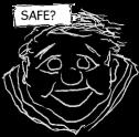
Comix and other mindful webworks examining the appeal of indulgences and the consequences of desire. LEGAL AND SAFE! But your mother might not approve.